Property Record Page (Images)
printed 2/2/2025 (page 6 of 6)
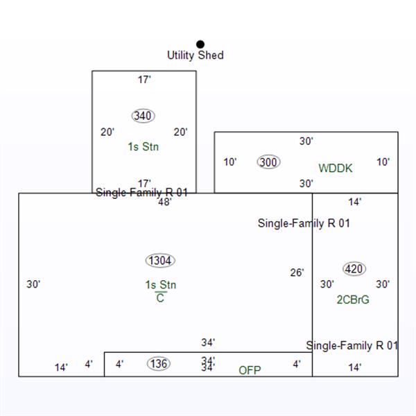
Sketch 1
printed 2/2/2025 (page 1 of 6)
| OwnerName | POVALERI GARY D & WANDA S |
|---|---|
| StateParcelNumber | 39-08-22-442-022.000-007 |
| ParcelNumber | 39-08-22-442-022.000-007 |
| MapNumber | |
| RoutingNumber | 22.000 |
| LegalDescription | 011-01197-00 LOT 51 HIGHLAND HGTS PLAT 4 11-26-2 2425 CEDARWOOD DR |
| Acreage | 0.0000 |
| LocationAddress | 2425 CEDARWOOD DR MADISON,IN 47250-0000 |
| OwnerAddress | 2425 CEDARWOOD DR MADISON,IN 47250-2380 |
| DeedBook | |
| DeedPage | |
| Document |
printed 2/2/2025 (page 2 of 6)
| TaxYear | Land | Impr | Total |
|---|---|---|---|
| 2021 PAY 2022 | 15000 | 111800 | 126800 |
| 2020 PAY 2021 | 15000 | 107200 | 122200 |
| 2019 PAY 2020 | 15000 | 97700 | 112700 |
| 2018 PAY 2019 | 15000 | 97700 | 112700 |
| 2017 PAY 2018 | 15000 | 96200 | 111200 |
| 2016 PAY 2017 | 15000 | 96200 | 111200 |
printed 2/2/2025 (page 3 of 6)
| Tax Year | Type | Amount |
|---|---|---|
| 2024 PAY 2025 | ||
| Standard Homestead | 48000 | |
| Supplemental Homestead | 47100 | |
| 2023 PAY 2024 | ||
| Standard Homestead | 48000 | |
| Supplemental Homestead | 41560 | |
| 2022 PAY 2023 | ||
| Standard Homestead | 45000 | |
| Supplemental Homestead | 32095 | |
| 2021 PAY 2022 | ||
| Standard Homestead | 45000 | |
| Supplemental Homestead | 28630 | |
| 2020 PAY 2021 | ||
| Standard Homestead | 45000 | |
| Supplemental Homestead | 27020 | |
| 2019 PAY 2020 | ||
| Standard Homestead | 45000 | |
| Supplemental Homestead | 23695 | |
| 2018 PAY 2019 | ||
| Standard Homestead | 45000 | |
| Supplemental Homestead | 23695 | |
| 2017 PAY 2018 | ||
| Standard Homestead | 45000 | |
| Supplemental Homestead | 23170 | |
| 2016 PAY 2017 | ||
| Standard Homestead | 45000 | |
| Supplemental Homestead | 23170 | |
printed 2/2/2025 (page 4 of 6)
| Tax Year | Spring | Fall | Due |
|---|---|---|---|
| 2021 PAY 2022 | |||
| 634 | 634 | 634 | |
| 2020 PAY 2021 | |||
| 1202.68 | 611 | 0 | |
| 2019 PAY 2020 | |||
| 563.5 | 619.86 | 619.86 | |
printed 2/2/2025 (page 5 of 6)
| Tax Year | As Of | # | Amount |
|---|
printed 2/2/2025 (page 6 of 6)